archeoviewer
Definitions. Graphic documentation: any product which defines the
morphology and the structural characteristics of archaeological evidence
(be it artistic or historical). This view does not affect the effectiveness of
drafting a paper on a computer (in the sense that the product exists and
is available from the commission, although in a limited way) but it
still lacks two requirements, which I believe are fundamental: In short, this is the possibility of having a number
of hyperlinks between the data on paper charts and other data. The above may seem trivial: these features are in
fact one of the prerogatives of the type of software known as GIS (Geographical
Information System) and which has been in operation for many years. However, we should consider the matter in detail,
beginning from the definitions. The GIS provides the management of this information
in a relational database. The aspect that characterizes the GIS is the
fact it is geometric: it stores the location of the data using a
projection system that defines the real position of the object. GIS
manages the same data from different systems and reference projection (eg
UTM or Gauss Boaga). Unlike paper maps, the scale in a GIS is a
parameter of quality of the data and not a display. The value of the
scale expresses the significant figures that should be considered valid
the geographic coordinates. The objective ot this project, however, is to broaden
the possible base of users, simplifying the means of access and
readability of information associated with map data. Strategy of the project. Following the argumentation exlained above, a key
aspect in this matter is the choice of the environment in which to
operate. The need to develop and assemble the information to
graph (chart documentation and graphics) in a type of CAD and GIS in a
rather narrow scope is of obvious importance. However, the usability of
the final product will be made possible by setting a specific number of
times, as flexibile as is possible, for end users, using simple and
affordable items. Assuming that, today, many of the programs makes the
inclusion of hyperlinks possible (or, you can connect to a file any
other document, even of different types, and run the application that
runs ), the problem remains of choosing the type of environment that is
more suitable. On the one hand, we have a sophisticated family of
GIS products and applications in CAD-specific maps (of which some,
especially the former, available as licensed freeware), which is
particularly efficient for the applications we are discussing, but
irretrievably linked to proprietary format. Such products, although
practically created for such uses, require a specific preparation for
their use and, in fact, discourage many potential users. Furthermore,
these licences can be expensive. On the other hand, we have the ability to produce (starting
from such applications as a vector in CAD) developed digital that can be
opened and managed by programs in common circulation, possibly
downloaded free from the Internet. These applications, in addition to
ease of use and costs (they are often included in packages that come
with operating systems) also have the advantage to manage very small
files, with considerable savings in hardware resources. Obviously, since
we are speaking of the need to see the map data on the monitor (vector
or raster), we must start from the possibility of transforming these
into images. To give some references, the two most popular formats
for viewing pictures (in our case, maps) are .PDF (managed by the family
of Adobe products) and .JPG which, as regards the management of
hypertext references, may be opened by all Internet browsers. The first,
also can partially print the data ( allowing the choice of "windows" of
lower printing of the "page" in the format which has been prepared), and
for both, it is possible to extract the portions to the functions of
"copy and paste" normal editor (also free on the network) to print them
for parts with an acceptable loss of resolution. The first (. PDF) can, however, display a highly
detailed video against an extreme compression of the file size compared
to the original and, above all, the images in. JPG. In both cases, the procedure for the production of
the end product should include: * A "raw" interim report from GIS or CAD program used
for the preparation of maps (the master of virtually all the work),
delivered as virtual print format .PDF or .JPG; The project of computerization of an archaeological
area. The first issue of an area where, over time, several
excavations have been conducted, study, restoration, protection and
documentation, is often fragmented data and, particularly, is almost
always exclusively on paper. In the area of graphic documentation of "historical"
archaeological sites, we can often find a whole series of drawings,
written at different times and in different ways, for portions (more or
less extended) of territory, which sometimes have few map references and
almost always no reciprocal links. Even ignoring the logistical
difficulties that officials face in managing such a heterogeneous mass
of documents, one of the key aspects of the problem lies in the actual
potential to protect the heritage and the opportunity to interact with
the various administrative entities that relate to it. This means managing a considerable amount of
information, making it more uniform and better linked (or rather,
georeferenced) to the local context to which they correspond. The draft of the Archeological computerized Charter
can be illustrated through the following objectives. In the future, you can then assign to each monument
(and consult dynamically) photos, cards, or texts, and detailed graphic
documentation (including raster drawings from paper archives),
bibliography, administrative documents, connecting such data from any
source: magnetic and optical local server or the Superintendent of the
Ministry, the Internet etc. Like data graphs, if the sites included in our
Charter, there are other types of documentation (for example: photos,
reports of excavations, U.S. sheets, drawings or materials, placing
orders, archival material, etc.). perhaps already in digital format, it
has not yet been possible to make it clear (and available) in the
context that we have described above. The ArcheoViewer project. After this (unfortunately) long introduction, we come
to the core of the matter. What we are proposing is basically an idea,
simple but revolutionary, which is still being developed , and which
will simplify the creation of GIS maps (and not only) and, above all,
broaden the base of people able to consult such data. This is not a new
program but, rather, a procedure (tendency of a protocol for the
encoding of a series of actions) for the production, editing and
managing of images and data. In parallel, this project is a system for the
creation of computer files and technical support for land management,
which is fully digital and integrated with all the scientific, technical
and administrative systems. In brief, it is a system with (almost) the
same functionality of a GIS, but it is much more simple, versatile,
economic (both venal and the hardware resources) and is so simple for
end-users to open, that anyone able to turn on a computer be able to use
it.
Mapping and computerization, the
archeoVIEWER
Project
We started the implementation of a Computerized Archaeological Map.
The concepts on this page, however, propose a method of work that goes
beyond the "simple" framework of the implementation of an archaeological
map. In fact, it can be applied to different contexts, such as the
computerization of administrative maps (not necessarily archaeological )
and / or of an old town centre, the documentation of a restoration,
macro and micro areas characterized by a local context, from scientific
and administrative documents, from graphic and photographic
documentation. It would take too long to make an assessment of the
potential offered by the procedures that we are going to discuss, so for
futher details we suggest you consult other works.
.gif)
demo 1
demo
2 demo 3
Here are some terms used in the text which we would like to clarify.
Text: any product developed which refers to an archaeological site (ditto)
including documentation, inventory, protection, administration and
management.
Original digital files: every item produced by the individual owners of
copyrighted programs that normally can be opened for editing only by
those programs. Sometimes the files can be viewed and / or printed by a
"parallel" (viewer) which does not perform editing functions.
Hyperlink (link): "text or graphic element in color which is
underlined. They can be clicked by users to open a file, or move to a
position within a file,to an HTML Web page or an HTML page on Intranet.
Hyperlinks can also be linked to sites and newsgroups Gopher, Telnet and
FTP "(using Windows). In short, it allows you, starting with a given
file, to open any other file using program that runs it.
The conditions are as follows.
The experience so far (in the creation of archaeological theme maps and
mapping, following the Charter) has clearly outlined the limits of such
operations which, essentially, are produced through the use of CAD
programs, or GIS, and, therefore, use only "technical", personnel,
including both external and internal personnel in the Archaelogical
Office that has commissioned the work. The final product, even if
delivered in an annex in the original digital format, are accessible and
modifiable only by those who have a good practice of such applications
and, especially, can work on computers with licensing programs. All
other potential users (staff, administrative staff and users for various
reasons) are satisfied with the drawings on paper or in the form of
images in. JPG,. TIF format, etc.. or, at most, the "parallel" programs
above.
* The opportunity to interact with other related digital information, in
graphic form (text, photographs) and, above all,
* The possibility of maintaining and updating of future scientific
activities in the same area by the users themselves, without having to
resort to professionals.
Some concepts must be clarified.
The "opportunity to interact with other information" means the
possibility that the Charter, in addition to the usual data layout on
evidence found in the area, contains other data, which can be purely
graphical (compiled on the other details on a major scale, etc..),
photographic (or recent or in the archives, satellite images, etc..),
administrative and protective (of the bond ordinances, acts on state
powers, for expert assistance, reports of archaelogical excavations,
etc. .), and finally, of a scientific nature (articles and publications,
web pages, etc.).. It is important to consider that the phrase , "also
contains further data" does not necessarily mean that they are actually
present in files that actually make up the Charter, but only that they
may be related to the context in question.
In other words, this is the opportunity to associate (as defined and
multiple criteria at the design stage) and make it interactive with all
other types of documentation which, although managed by different
programs and from disparate sources (memory to disk, server network, web
etc.) are usually displayed and viewed on a computer monitor or through
simple digital archiving, which is currently only available in paper
form.
"The possibility of maintaining and updating" the Charter is perhaps the
main emphasis of this work: to give the opportunity for the project
managers of the information collected in digital form, to integrate it
in the future (once the Charter) with the additional material which,
inevitably, is produced by working in a given geographical area.
Burrough (1986) defined as follows: "The GIS consists of a set of
software tools to capture, store, extract, process and display spatial
data from the real world." This is a system capable of producing,
managing and analyzing spatial data associated with each geographical
feature one or more alphanumeric descriptions. The GIS is different from
the DBMS (or Database Management System) as it essentially prepares and
handles georeferenced data, which in turn can be stored in a DBMS and
individual files. SIT is the Italian acronym for Land Information
System, and coincides with the English translation, Geographical
Information System. Mogorovich (1988) defined the spatial information
system as follows: "The men, tools and procedures (often informal) that
allow the acquisition and distribution of data within the organization
and make them available when required to those who need to carry out any
activities. "
Data model.
For the representation of data, a computer system must be formalized by
a representative model flexible to fit the real phenomena. In GIS, we
have three types of information:
Geometric: relative to the mapping of the objects represented, such as
the form (point, line, polygon), the size and location;
Topological: referring to the mutual relations between objects
(connection, adjacency, inclusion, etc. ...);
Information: about the data (numeric, text and so on ...) associated
with each object.
(from wikipedia heading Geographic Information System, italian version,
available at:
http://it.wikipedia.org/wiki/Sistema_informativo_geografico
A natural question follows: if the GIS already does all these things,
where is the problem? Well, the problem is that these things are only
done by the GIS, or a specific type of program, which is often
complicated to use, almost always very expensive (although there are
several versions of freeware and open source, see http://www.gfoss .com
/ drupal /), and, therefore, puts off a large proportion of potential
users.
* An elaboration from a proprietary file format. PDF or. JPG (in the
first case Adobe Acrobat, in the second one of many html pages managers)
for the inclusion of hyperlinks.
1. Acquisition of a digital cartographic base (possibly georeferenced),
from local governments, in order to have a common basis "for dialogue"
with local administrations regarding administrative acts to protect the
territory.
2. Reconnaissance in the archives of the Archaelogical Office (and all
the institutions that carry out interventions excavations or studies in
the area) to find all the projects that have been produced over time and
make a selection according to criteria of priority and reliability.
3. Construction of a geo-topographic base for the exact location of
archaeological evidence and, above all, to link several pieces of
documentation that have been produced in recent times with modern
criteria, in order to establish a unique protocol for future documenting.
4. Digitization of the archives and insertion of the processed items in
the same placement in the general map, with the possibility of hypertext
links and, above all, dynamic update of the Charter to unique criteria
reference.
5. Production of results for the consultation of the Paper at different
levels and according to established themes, with the ability to handle
combinations of data in different ways.
Once built, (in CAD or GIS) it will be possible to include any other
type of data related to the single archaeological evidence, to be
managed as a hypertext reference.
In the above-mentioned list, steps 1 through 4 have to be made in CAD
and, therefore, as stated above are in fact a prerogative of a "technical"
elite (internal or external supervision to the Archaelogical Officethat
has commissioned the work) In other words, external help is required
from people able to use these programs for both licenses. This is
nothing new, in the sense that this procedure is normally used for the
production of "classic" processes (that prints on paper), delivered
vector files for archiving or images in various raster format to be
accessed without using the owner programs.
This type of material, subject to the validity and quality of the work,
has only one flaw: it is not possible to link it to other data of any
kind (which exist or be created in the future), including graphics; in
ther words, this is static material. Furthermore, probably the
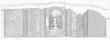
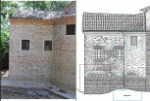
structures included in the plan georeferenced vector format (with only
the perimeter of the building and the main elements with graphics with a
scale of 1:500-1:200 ) will surely have the details with a
characterization to a larger scale (eg 1:50) and, probably, sections and
tables. In both cases, when these products have been developed in vector
format or in "traditional" form (drawings on glossy or polyester,
possibly digitized using scanners), the consultation must take place
separately from that of the Charter, without the possibility of dynamic
connections.
Learn more:
professional curriculum
go to demo 1
go
to
demo 2
go to demo 3
follow on this site the evolution of project
home page
up